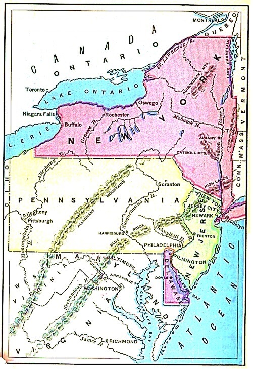
QUESTIONS - Examine the map and answer the questions. Select States of the Northeast
How many northeastern states are featured in color on the map?
Which is the largest featured state on the map?
Which is the second largest state featured on the map?
Which is the third largest state featured on the map?
Which is the smallest map featured on the map?
Which country is north of New York?
Which two lakes are shown on the map?
Which large river is in the eastern part of New York?
Which large river is in the western part of New York?
Which river flows between Pennsylvania and New Jersey?
Which large river flows through the eastern part of Pennsylvania?
Which two rivers meet in the western part of Pennsylvania?
Which large river flows northeast from Lake Ontario?
Which mountains are in Pennsylvania?
Which mountains are in New York?
Which bay is between New Jersey and Delaware?
Which states are directly south of New York?
Which states are directly east of New York?
Where is Lake Erie?
Where is Lake Ontario?
Where is the Hudson River?
Where is the St. Lawrence?
Into what lake does the Genesee River flow?
Which lake is northeast of New York?
ANSWERS
Four northeastern states are featured in color on the map.
New York is the largest featured state on the map.
Pennsylvania is the second largest state featured on the map.
New Jersey is the third largest state featured on the map.
Delaware is the smallest map featured on the map.
Canada is north of New York.
Ontario and Erie are two lakes shown on the map.
The Hudson River is in the eastern part of New York.
The Genesee River is in the western part of New York.
The Delaware River flows between Pennsylvania and New Jersey.
The Susquehanna River flows through the eastern part of Pennsylvania.
The Allegheny River and Monongahela River meet in the western part of Pennsylvania.
The St. Lawrence River flows northeast from Lake Ontario.
The Allegheny Mountains are in Pennsylvania.
The Adirondack Mountains are in New York.
Delaware Bay is between New Jersey and Delaware.
Pennsylvania and New Jersey are directly south of New York.
Vermont, Massachusetts, and Connecticut are directly east of New York.
Lake Erie borders Canada, New York, Pennsylvania, and Ohio.
Lake Ontario borders Canada and New York.
The Hudson River is in eastern New York.
The St. Lawrence River runs on the border between Canada and New York.
The Genesee River flows into Lake Ontario.
Lake Champlain is northeast of New York.
Notebook Work: Label the following on the map of the northeast United States: Canada, the Atlantic Ocean, Lake Ontario, Lake Erie, New York, Pennsylvania, New Jersey, and Delaware.
 First Lessons in World Geography
World Geography
First Lessons in World Geography
World Geography


 About
About Curriculum
 Navigation